THE EXPLORER’S FIELD ATLAS · TERRAIN READING
The Land Is a Map—If You Know How to Read It.
Learn how ridgelines, valleys, streams, slopes, and natural landmarks reveal the shape of the terrain and help explorers understand their surroundings.
⛰️
RIDGELINES
🏞️
VALLEYS
🧭
NAVIGATION
Long before satellite maps and smartphone navigation became common, explorers relied on careful observation of the landscape.
Mountains, valleys, rivers, coastlines, and distinctive landforms helped people understand where they were and how different parts of the terrain connected.
Even today, the ability to read a landscape remains valuable.
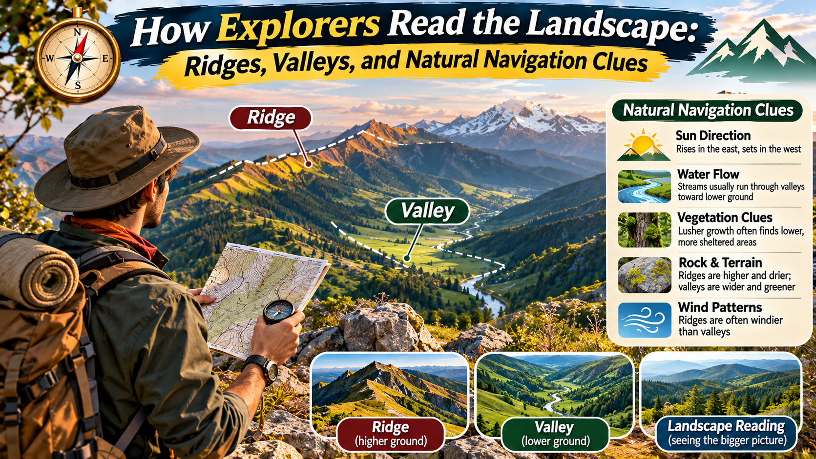
A ridge can reveal the direction of higher ground. A valley can show where water collects and flows. A distinctive peak may help confirm a location when compared with a map.
These observations are part of a skill often called terrain reading or landscape interpretation.
Terrain reading does not mean guessing your location from a single natural feature. It involves combining multiple clues, understanding how landforms develop, and comparing observations with reliable navigation tools.
Whether you are studying geography, planning a hiking route, or simply trying to understand a mountain landscape, these principles can make outdoor environments easier to interpret.
This guide explains how explorers recognize ridges, valleys, slopes, drainage patterns, and other natural navigation clues—and how to use that knowledge responsibly.
What Does It Mean to Read a Landscape?
Reading a landscape means observing the physical features of an area and interpreting what they reveal about the terrain.
Instead of seeing hills, streams, and forests as unrelated objects, a skilled observer looks for relationships between them.
For example, water generally moves downhill under gravity. Streams often occupy low areas, while ridges separate neighboring drainage basins.
These relationships can help someone understand the arrangement of landforms even when only part of the landscape is visible.
Landscape reading typically involves three connected skills:
- Observation: Identifying visible features such as ridges, valleys, slopes, and watercourses.
- Interpretation: Understanding how those features relate to elevation, drainage, and surrounding terrain.
- Verification: Comparing observations with a topographic map, compass, GPS device, or other reliable information.
Verification is particularly important because natural features can be misleading when viewed from unfamiliar angles.
FIELD PRINCIPLE
Observe the shape. Understand the relationship. Confirm the location.
Good navigation combines terrain awareness with dependable tools rather than relying on one landmark or environmental clue.
1. Understanding Ridges and Ridgelines
A ridge is an elongated area of relatively high ground.
Ridges may connect mountain summits, form the boundaries between valleys, or extend outward from larger mountain systems.
A ridgeline generally follows the higher ground along the crest of a ridge.
From a distance, ridges often appear as continuous elevated shapes against the horizon.
However, ridgelines may include small peaks, saddles, and changes in elevation.
Why Ridges Are Useful Landmarks
Ridges can help explorers understand the structure of mountainous terrain.
They may provide views across neighboring valleys and reveal the location of nearby peaks.
Because ridges often separate drainage areas, they can also help explain why streams flow in different directions on opposite sides.
When matched with a topographic map, a distinctive ridge can help confirm an observer’s position.
Challenges of Ridge Travel
Although ridges may appear straightforward from a distance, they are not necessarily safe or easy travel routes.
Some contain cliffs, exposed rock, unstable ground, narrow sections, or steep drops.
Weather conditions may also be more severe on exposed high ground.
Ridges should therefore be understood as terrain features, not automatic recommendations for route selection.
2. How Valleys Reveal the Shape of the Land
A valley is a relatively low area between higher areas of land.
Valleys are commonly shaped by flowing water, glaciers, or a combination of geological processes.
Many contain streams or rivers, although some valleys are dry or contain intermittent watercourses.
Valleys are useful for terrain interpretation because they often show how surrounding slopes connect to drainage systems.
V-Shaped Valleys
V-shaped valleys are commonly associated with river erosion.
Over time, flowing water can cut downward into rock and sediment, while weathering and slope processes shape the valley sides.
These valleys are often found in upland or mountainous landscapes.
U-Shaped Valleys
U-shaped valleys are commonly associated with glacial erosion.
Large glaciers can widen and deepen existing valleys, leaving broad floors and steep sides.
These landforms are especially noticeable in landscapes previously affected by extensive glaciation.
Why Valleys Matter for Navigation
Valleys can help observers identify drainage patterns and the relative position of surrounding high ground.
They may also contain established paths, roads, or settlements.
However, following a valley is not always practical or safe.
Valley floors can contain steep ravines, dense vegetation, waterfalls, unstable slopes, or areas vulnerable to flooding.
3. Saddles, Spurs, and Other Important Landforms
Ridges and valleys are only part of the terrain.
Several smaller landforms can help explain how a landscape fits together.
Saddles
A saddle is a relatively low area between two higher points along a ridge or mountain system.
It may appear as a dip between peaks when viewed from the side.
Saddles can be distinctive features on topographic maps.
Spurs
A spur is a smaller ridge or projection of higher ground extending from a larger ridge or hillside.
Spurs often separate small valleys or drainage channels.
Recognizing them can help explain the arrangement of slopes.
Summits
A summit is a local high point.
Prominent summits can serve as useful landmarks when their shape and location match a map.
However, several nearby peaks may look similar, especially in poor visibility.
Escarpments
An escarpment is a steep slope or cliff-like feature separating areas of different elevation.
Escarpments can be visually distinctive but may also create major obstacles to travel.
4. How Water Reveals Terrain Patterns
Water is one of the most useful clues for understanding the shape of a landscape.
Under normal conditions, surface water flows downhill under gravity.
Streams collect water from surrounding slopes and often join larger watercourses.
These connections create drainage networks.
By observing where streams converge, explorers can begin to understand the structure of the surrounding valleys.
Drainage Basins
A drainage basin is an area of land where precipitation and surface runoff drain toward a common outlet.
The boundaries between neighboring drainage basins are called drainage divides.
These divides often follow ridges or other high ground.
Understanding drainage basins helps explain why two streams on opposite sides of a ridge may eventually flow into different river systems.
Stream Junctions
A confluence occurs where two or more streams meet.
Distinctive stream junctions can be useful reference points on a map.
However, stream channels can change over time, and seasonal waterways may not always contain visible flowing water.
Why Water Should Not Be Treated as a Guaranteed Route
Following a stream does not guarantee that it will lead to a road, settlement, or safe exit.
Watercourses may enter steep gorges, waterfalls, marshes, or remote terrain.
They can also rise rapidly during heavy rainfall.
Water features are valuable navigation references, but route decisions should be based on verified maps and current conditions.
5. Reading Contour Lines on a Topographic Map
A topographic map represents the shape of the land using contour lines.
Each contour line connects points of equal elevation.
By studying the spacing and shape of these lines, readers can identify slopes, ridges, valleys, and summits.
| Contour Pattern | Likely Terrain Meaning |
|---|---|
| Closely spaced lines | Steeper slope |
| Widely spaced lines | Gentler slope |
| Closed concentric contours | May indicate a hill or depression, depending on labels and symbols |
| Contours crossing a stream valley | Often form V-shapes pointing upstream |
| Contours around a saddle | Show lower ground between higher areas |
Contour interpretation requires attention to elevation labels, contour intervals, and map conventions.
A pattern that looks like a hill may represent a depression if the map uses special depression contours.
Combining contour patterns with real-world observations improves accuracy.
6. Matching Visible Landmarks With a Map
Distinctive landforms can help establish where an observer is located.
A recognizable mountain peak, river bend, lake, or valley junction may be useful when it can be matched confidently to a map.
The most reliable approach is to compare several independent features.
For example, an observer might identify a prominent peak, a nearby saddle, and a river valley.
If their relative positions match the map, confidence in the location estimate increases.
However, visual appearance changes with viewing angle and weather conditions.
Distances can also be difficult to judge in mountainous terrain.
When accurate navigation is required, use a properly oriented map, compass, or GPS rather than visual estimation alone.
7. Using the Sun as a General Direction Clue
The Sun can provide broad directional information, but its position changes with time, season, and latitude.
In many locations, the Sun rises generally in the eastern part of the sky and sets generally in the western part.
However, it rises due east and sets due west only around the equinoxes for most locations.
The Sun’s midday position also varies by hemisphere, latitude, and season.
Therefore, simple statements such as “the Sun is always in the south at noon” are not universally correct.
Solar observations can support general orientation, but they should not replace a compass or reliable map when precise direction matters.
Why Shadows Change
Shadows change direction and length as the Sun moves across the sky.
Their behavior depends on local time, geographic location, and season.
Observing shadows over time can demonstrate the Sun’s apparent movement.
However, estimating direction from a single shadow without knowing the conditions can produce errors.
8. Vegetation and Weather as Supporting Clues
Vegetation can reveal information about moisture, sunlight, soil, and exposure.
For example, shaded slopes may support different plant communities from nearby sunny slopes.
Valley bottoms may contain vegetation associated with wetter conditions.
Wind-exposed ridges may support shorter or more resilient plant growth.
However, vegetation is not a universal compass.
Moss does not reliably grow only on the north side of trees.
Its distribution depends on moisture, shade, bark characteristics, and other environmental factors.
Similarly, tree shape and branch growth can be influenced by many local conditions.
Vegetation is most useful for understanding habitat conditions rather than determining an exact compass direction.
9. Recognizing Natural Navigation Clues in Different Landscapes
Landscape-reading skills apply to many environments, but the most useful features vary.
Mountain Landscapes
Prominent ridges, summits, saddles, and drainage valleys may provide useful references.
Elevation changes can be substantial, and visibility may change quickly with weather.
Forested Landscapes
Dense tree cover can limit long-distance views.
Streams, slope direction, trail junctions, and distinctive terrain features may become more important.
However, similar-looking forest environments can make navigation difficult.
Coastal Landscapes
Headlands, bays, estuaries, and coastal ridges can provide recognizable features.
Tides and changing shoreline conditions must be considered.
Open Grasslands and Plateaus
Broad horizons can make distant landmarks visible.
However, subtle terrain changes may be difficult to interpret without a map.
10. Common Mistakes When Reading Terrain
Landscape interpretation becomes less reliable when observers make assumptions without checking them.
Several mistakes are particularly common.
- Confusing similar peaks: Nearby summits may look alike from different viewpoints.
- Assuming every valley contains a stream: Some valleys are dry or contain seasonal drainage channels.
- Following water without a route plan: Streams may lead into hazardous terrain.
- Overestimating visible distances: Mountain landscapes can distort perceptions of scale.
- Relying on folklore: Moss, tree branches, and other natural features are not dependable standalone compasses.
- Ignoring weather: Fog, rain, snow, and darkness can make familiar landmarks difficult to recognize.
The most effective way to reduce these errors is to verify observations using multiple sources of information.
11. A Practical Landscape-Reading Exercise
You can practice terrain interpretation in a safe location with a clear view of the surrounding landscape.
A public viewpoint, marked hiking trail, or accessible hilltop can provide useful opportunities.
Begin by identifying prominent landforms without trying to navigate anywhere.
Look for the highest visible points, the lower areas between them, and any streams or drainage channels.
Then compare your observations with a reliable topographic map.
EXPLORER’S FIELD NOTE · PRACTICE EXAMPLE
Reading a Mountain Valley
Observation 1: A long ridge runs across the horizon.
Observation 2: A lower valley lies between two elevated areas.
Observation 3: A stream appears to follow the valley floor.
Map comparison: The ridge, valley, and stream appear in matching relative positions.
Conclusion: Multiple matching features support the interpretation, but the exact location should still be verified.
This fictional example demonstrates a useful observation method without requiring off-trail travel or risky route decisions.
12. Why Modern Explorers Still Need Terrain Awareness
Digital navigation has made maps and location information widely accessible.
However, electronic devices can lose power, experience signal limitations, or display incomplete information.
Terrain awareness helps people interpret what a map shows and recognize when a planned route may involve difficult ground.
It also improves geographic understanding.
Learning how ridges, valleys, and drainage networks connect can make maps easier to understand and landscapes more interesting to explore.
For outdoor travel, terrain awareness should complement—not replace—appropriate equipment, route planning, weather information, and established safety practices.
13. Safe Navigation Habits for Outdoor Exploration
Good landscape interpretation is most valuable when combined with responsible planning.
Before entering unfamiliar terrain, review an appropriate map and identify established routes.
Check the weather forecast and understand local hazards.
Carry suitable navigation equipment and know how to use it.
In remote areas, inform a trusted person about your intended route and expected return.
Avoid treating an unverified natural clue as sufficient reason to leave a marked trail.
If you become uncertain of your location, avoid continuing blindly into unfamiliar terrain.
Stop in a safe place, assess your available information, and use appropriate navigation or emergency assistance resources.
Frequently Asked Questions
What does it mean to read the landscape?
Reading the landscape means identifying landforms and interpreting their relationships to elevation, drainage, and surrounding terrain.
How can ridges help with navigation?
Ridges can provide recognizable landmarks and help explain the boundaries between drainage basins when compared with a map.
What is the difference between a ridge and a valley?
A ridge is an elongated area of relatively high ground, while a valley is a lower area between higher terrain.
Do contour lines show elevation?
Yes. Contour lines connect points of equal elevation and help represent the shape and steepness of the land.
Can the Sun be used to find direction?
The Sun can provide general orientation clues, but its position varies with time, season, and latitude. A compass is more reliable for precise bearings.
Does moss always grow on the north side of trees?
No. Moss growth depends on local moisture, shade, and other conditions, making it an unreliable standalone direction indicator.
Is following a river a safe navigation strategy?
Not necessarily. Rivers and streams can lead through dangerous terrain and should not be followed without a verified route plan.
Why is terrain reading still useful with GPS?
Terrain reading helps users understand maps, recognize landforms, and evaluate route conditions. It complements digital navigation rather than replacing it.
Final Thoughts
Ridges, valleys, streams, and other landforms reveal important information about the structure of a landscape.
By learning how these features connect, explorers can better understand elevation, drainage patterns, and the arrangement of surrounding terrain.
Natural landmarks may also help confirm a location when compared with reliable maps and navigation tools.
However, no single clue is universally dependable.
Terrain interpretation works best when observations are checked against multiple sources of information.
Developing this skill can make geography more meaningful, improve outdoor awareness, and deepen appreciation for the natural processes that shape the land.
Ultimately, learning to read a landscape is not about replacing modern navigation. It is about understanding the world that the map represents.
THE EXPLORER’S TAKEAWAY
Ridges Reveal High Ground. Valleys Reveal Drainage. Maps Connect the Clues.
The strongest navigation skill is not guessing from nature—it is combining careful observation with reliable geographic information.